
When winter winds sweep across the Great Lakes, they often bring a stunning weather event known as lake effect snow. This phenomenon can turn peaceful cities into deep snow zones within hours. Some areas get buried under several feet of snow, while nearby towns stay almost clear.
This unique snowfall pattern has a fascinating science behind it and a major influence on communities across the northern United States. Understanding it helps people prepare better and stay safe when these localized snowstorms strike.
What Is Lake Effect Snow
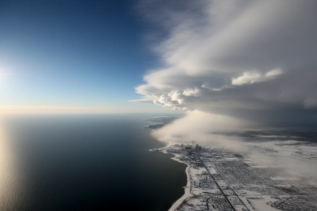
Lake effect snow occurs when cold air passes over warmer lake water. The air absorbs heat and moisture from the surface. As it moves inland and cools, the moisture condenses and falls as snow.
Unlike widespread winter storms, this type of snow happens in narrow, intense bands. It can produce several inches per hour, affecting small areas while leaving nearby regions almost untouched.
According to the National Weather Service, lake effect snow develops when the temperature difference between the lake and the air above is at least 23 degrees Fahrenheit. That temperature gap drives convection and heavy snowfall.
Where Does Lake Effect Snow Occur
Lake effect snow mainly affects communities along the Great Lakes. The heaviest snowfalls often occur downwind of Lake Erie, Lake Ontario, Lake Michigan, Lake Huron, and Lake Superior.
Cities such as Buffalo, Rochester, Cleveland, and Erie are well known for their snow-covered winters. In Michigan, towns near Lake Superior and Lake Michigan regularly experience thick snow belts each year.
The reason is simple. Cold winds moving over the long expanse of water pick up moisture and carry it inland. The longer the wind travels across the lake, the heavier the snow on the other side. This distance is called the “fetch.”
Other places like Utah’s Great Salt Lake can also produce similar effects, though the Great Lakes remain the most active region in the United States.
When Does Lake Effect Snow Happen
Lake effect snow usually appears from late November to February. It happens when cold Arctic air from Canada moves over the relatively warm, unfrozen waters of the Great Lakes.
Early in the season, the lakes are still open and warm, so conditions are ideal for moisture exchange. As the lakes start freezing in mid or late winter, snow production weakens because ice reduces evaporation.
One of the most remarkable examples occurred in November 2022 when parts of Buffalo recorded more than 70 inches of snow in a single storm — one of the heaviest in history.
Who Is Affected by Lake Effect Snow
Lake effect snow impacts millions of people across the Great Lakes states. Homeowners, drivers, airport workers, and local authorities must all adapt quickly when snow bands form.
Roads can become slippery and dangerous. Visibility often drops to near zero during heavy bursts. Power lines and roofs face strain from the weight of accumulated snow.
City governments deploy plows around the clock to keep streets open. Residents shovel sidewalks and clear rooftops. Businesses often close temporarily, and schools delay classes for safety reasons.
Airports in cities like Buffalo and Cleveland face flight cancellations when these intense snow bands hit.
The National Weather Service issues lake effect snow warnings to alert communities in advance, helping save lives and reduce damage.
Why Lake Effect Snow Happens
The cause of lake effect snow lies in the sharp temperature contrast between lake water and cold air. When icy winds blow across warm lake surfaces, water vapor rises into the air. This moisture then cools and condenses as the air travels inland, forming snow clouds.
Several factors decide how severe the snow becomes:
- Fetch length: The longer the air passes over the water, the more moisture it collects.
- Wind direction: Steady winds create strong, narrow snow bands.
- Topography: Higher elevations inland enhance lifting and snowfall.
- Lake ice: As lakes freeze, less evaporation means weaker snow.
According to NOAA, when the air above is at least 13 degrees Celsius colder than the lake surface, conditions are perfect for lake effect snow.
How Lake Effect Snow Develops
The process unfolds step by step:
- Cold air moves across open lake water.
- The lake warms the air and adds moisture.
- Moist air rises and cools, forming clouds.
- Winds carry the clouds inland.
- Snow falls once the air reaches land and cools further.
- The process continues as long as conditions remain favorable.
Some snow bands stay fixed over one spot for hours, dropping heavy snow at rates exceeding two inches per hour. A small change in wind direction can shift the snow band entirely, leaving one town buried and another untouched.
What Are the Impacts and Hazards of Lake Effect Snow
Lake effect snow can create serious hazards.
Driving conditions deteriorate quickly as visibility drops in sudden whiteouts. Pileups often occur on highways because drivers cannot see ahead. The weight of snow can collapse roofs or snap trees and power lines.
Emergency services respond to stranded travelers and blocked roads. Cities spend millions on plowing, salting, and recovery after major events.
Economic impacts extend to airports and shipping routes as flights and deliveries face delays. For example, Great Lakes ports sometimes close due to snow and ice buildup.
Despite the disruption, residents in snowbelt regions have learned to prepare well. From reliable heating systems to snow removal equipment, local adaptation helps reduce the overall risk.
When Are Lake Effect Snow Warnings Issued
The National Weather Service issues alerts to warn communities before and during these events.
- Lake Effect Snow Watch: Conditions are favorable for a possible event within 24 to 48 hours.
- Lake Effect Snow Warning: Heavy snow is expected or already occurring.
- Lake Effect Snow Advisory: Lighter but still impactful snow is expected.
Warnings typically apply when six or more inches of snow are predicted within 12 hours. Residents are urged to avoid travel, stock essentials, and stay updated through NOAA alerts or local radio.
Current Trends and Climate Influence
In recent years, scientists have noticed that climate change might influence lake effect snow.
Warmer lake temperatures can increase evaporation, potentially producing heavier snowfall in early winter. However, as the climate warms, the duration of lake effect snow seasons may shorten. Lakes might freeze later, and cold outbreaks may become less frequent.
Meteorologists expect that the 2025 winter could bring strong early-season events across the Great Lakes due to warmer water temperatures mixed with Arctic air outbreaks.
How to Prepare for Lake Effect Snow
Preparation is vital in regions prone to these snowstorms.
Here are essential tips:
- Keep a winter emergency kit with food, water, and blankets.
- Stay home during warnings unless travel is necessary.
- Clear snow from rooftops and pathways to prevent damage.
- Maintain backup heating options.
- Follow trusted local weather updates regularly.
Preparation reduces risk, protects property, and ensures personal safety during heavy snow periods.
Frequently Asked Questions
What causes lake effect snow compared to normal snow?
Lake effect snow occurs when cold air flows over warm lake water, while regular snow forms from large frontal systems.
Which states experience the most lake effect snow?
New York, Michigan, Ohio, and Pennsylvania see the most frequent events.
How long can lake effect snow last?
It can last several hours to multiple days depending on lake and wind conditions.
Does climate change affect lake effect snow?
Yes. Warmer lakes can create heavier snowfall early in winter, but overall season length may decrease.
What should drivers do during a lake effect snow warning?
Avoid travel if possible. Drive slowly, use headlights, and keep a safe distance from other vehicles.
Why do some towns get more snow than others nearby?
Because snow bands are narrow and stationary. A small wind shift can change their position dramatically.
Conclusion
Lake effect snow is one of nature’s most captivating and unpredictable winter events. It showcases how air, water, and temperature work together to shape weather in remarkable ways.
While it can cause severe travel disruptions and power outages, understanding this phenomenon allows people to prepare better and stay safe.
Communities across the Great Lakes have learned to live with the challenges it brings every winter. As climate conditions evolve, lake effect snow remains a defining feature of northern America’s weather story — both a beauty and a test of endurance.
References
- National Weather Service – www.weather.gov
- NOAA Climate and Weather Division – www.noaa.gov
- SciJinks by NASA – scijinks.gov/lake-snow
- Spectrum Local News – spectrumlocalnews.com
- AccuWeather Reports – accuweather.com
- Michigan Sea Grant Research – michiganseagrant.org
- Fox Weather – foxweather.com